

From Maryland to the Caribbean to Asia, Record-Hot Ocean Waters Give Extreme Weather Potentials a Big Boost
27
September, 2016
The
forecasts began coming in this morning: Heavy
rainfall expected over the next two days.
Possible flash flooding. Turn around, don’t drown.
These advisories
buzzed up from local news media for the DC, Maryland, and
Northern Virginia metro areas as a crazy, wavy Jet Stream spawned an
upper-level low that’s predicted to gorge on an insane amount of
moisture spewing up off the record-hot Atlantic Ocean.
Forecast GFS
model guidance shows
an upper-level low-pressure system situated over the Great Lakes
region in association with a big trough dipping down from the Arctic.
Over the next 24 to 48 hours, the low is expected to shift south and
east. Becoming cut off from the upper-level flow, the low is then
predicted to set up a persistent rainfall pattern over DC, Maryland
and Northern Virginia.

(NOAA’s
precipitation forecast model shows extreme rainfall predicted for the
DC area over the next seven days. Note that record global heat and,
in particular, excessively hot sea-surface temperature anomalies off
the U.S. east coast are providing an unprecedented amount of fuel for
storms. Should such storms fire off, they could produce rainfall
totals in excess of those currently predicted. Image source: NOAA.)
Easterly
winds are expected to be drawn into the low from a record-hot
Atlantic Ocean. These winds will bear upon them an extraordinary
burden of atmospheric moisture which has been continuously
evaporating up from a very warm Gulf Stream. Such moisture is fuel
for powerful rainstorms. Given the destabilizing kick provided by the
upper-level low, it is expected to deliver some pretty intense
downpours on Wednesday, Thursday and Friday.
NOAA
model guidance shows rainfall amounts of 3 to 6 inches over the area
for the next five days. However, given the high atmospheric moisture
content and the record atmospheric and ocean heat that’s spiking
storm energy potentials, there is a possibility for locally higher
amounts.
Extreme
Ocean Heat Contributes to Severe Weather
As
the DC area prepares for what could be another record or near-record
rainfall event, various other regions over the Atlantic and on the
other side of the world are also facing the possibility of
intense weather. Very warm sea-surface temperatures are the
common thread that links all these events.
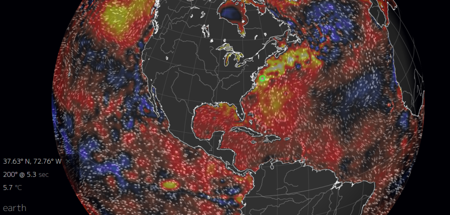
(Hot
sea surfaces are loading up the atmosphere with moisture and helping
to produce convective updrafts that heighten storm tops. Such are the
results of climate change, which has now dumped an extraordinary
amount of heat energy into the Earth’s ocean and atmosphere —
energy that now provides fuel for both extreme rainfall events and
more-intense hurricanes. Image source: Earth
Nullschool.)
In
the Atlantic Ocean, just off Maryland and DC, sea-surface
temperatures running at an amazing 5.7 degrees Celsius above
average are
helping fuel this week’s possible extreme rainfall event. For
reference, ocean temperatures over the course of the 20th century
tended to range between 2 C above average to 2 C below average. Any
deviation beyond a 2 C departure for any significant length of time
was considered pretty out of the ordinary. But off the U.S. east
coast over the past couple of years and concurrent with record-hot
global temperatures, sea surfaces have regularly hit such high
ranges. The heat bleeding off those waters has contributed to a
growing number of intense precipitation events.
Possible
Strong Cyclone to Form in Caribbean, Track Toward U.S. Coast
Farther
south, the Caribbean is also quite hot. Ranging from 1-2 C above
average, this region of warmer-than-normal ocean water is about to
receive a
strong tropical wave running in from the east.
Over the next week, this wave is expected to gorge on these hot
waters, firing off intense thunderstorms with rising tops around a
tightening center of circulation, and developing into a tropical
cyclone that could reach hurricane strength by late this week or
early next week. Long-range model runs predict all kinds of possible
rough weather related to this potential storm for the U.S. east or
Gulf coasts or even for the Canadian Maritimes.

(Most
recent ECMWF model run shows an extremely powerful 938-millibar
hurricane threatening southeast Florida on October 7. If such a storm
does form, it will be fueled by hotter-than-normal ocean conditions
brought about by human-caused climate change. Image source: Tropical
Tidbits.)
One
of the most accurate forecast models, the European Centre for
Medium-range Weather Forecasting (ECMWF), is pointing toward the
possibility of a major hurricane of 938-mb intensity threatening the
southeast coast of Florida by October 7. Though such long-range
forecasts are highly uncertain so far out, the underlying models are
obviously picking up on the potential energy provided by all that
ocean heat. The result is a kind of climate roulette — with a few
extra bullets in the chambers. In other words, with all that ocean
heat laying around, the potential for a big storm is just sitting
there, waiting for something big to come along and suck it up. This
ongoing, worsening situation could result in some serious added
weather consequences over the next ten days or so.
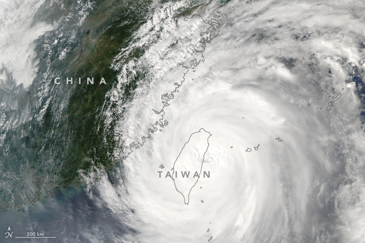
Megi is Third
Tropical Cyclone to Impact Taiwan
All
across the world this year, big rainfall and related storm events
have been popping up. Louisiana alone saw two 30-inch plus rainfall
events while nearby Texas got hit again and again and again. This
week, major
floods in Iowa spurred officials to urge thousands to evacuate.
Meanwhile, the recent Ellicott City, Maryland flood has people in the
DC area on edge over this week’s potential for very heavy rainfall.
Half
a world away today, Typhoon Megi
roared ashore in Taiwan as a Category 4 tropical cyclone with top
sustained winds of 132 miles per hour. Knocking
out power for 3 million people across the island,
the storm is
now reported to have resulted in 250 injuries and the loss of 4
lives.
Meanwhile, as much as 36
inches of rain has
fallen over parts of the island.
It’s
worth noting that rainfall hasn’t stopped over Taiwan yet, even as
the massive circulation of Megi plows toward China — which is
likely to receive heavy rainfall from the storm as well.
Like
the possible extreme weather events related to very-hot surface
waters in the North Atlantic and Caribbean, Megi formed over waters
that are 1-3 C hotter than normal. But what’s a bit odd about Megi
is that she followed almost in the exact tracks of two other cyclones
— one which brushed by just to the north of Taiwan, and another
which skirted the island’s south side. Typically, upwelling of
cooler waters caused by hurricanes and tropical storms is enough to
prevent an immediate follow-on by powerful systems, due to the fact
that surface waters tend to be warmer than waters below the surface.
But Megi followed these two systems and was able to tap enough ocean
heat to reach Category 4 intensity even as it supported a massive
outflow.
How
did this happen? Well, considering the fact that ocean surfaces in
Megi’s path are still 1-2 C hotter than normal, it’s likely that
the waters at depth were also much warmer than usual,
meaning storm-related upwelling wasn’t able to limit
the strength of follow-on storms. This possible new feature of the
Western Pacific raises the strange potential for regions to be hit
by a train of tropical storms and cyclones, as happened with Taiwan
over the past couple of weeks.
Conditions
in Context — Record-Hot Ocean, Atmosphere Fuels More Severe Storms
The
common link between the forthcoming potential severe weather
along the U.S. east coast and the intensity of Typhoon Megi upon
following behind two other storms is increased ocean heat. Such
heat acts as a kind of energy and moisture engine for more, and more
powerful, storms, such as the aforementioned extreme rainfall events
and powerful, peak-intensity cyclones. In short, these are aspects of
a world undergoing fundamental climate shifts — shifts that
continue to ramp up due to the great and ongoing emission of
greenhouse gasses into the Earth’s atmosphere.
Links:
Scientific
Hat tip to Dr. Jeff Masters
Hat
tip to DT Lange
Hat
tip to Colorado Bob
No comments:
Post a Comment
Note: only a member of this blog may post a comment.