

Monster El Nino Emerging From the Depths — Sea Surface Temperatures Hit Strong Event Threshold
13
July, 2015
Last
year’s warnings from this blog of a possible extreme heat eruption
in the Equatorial Pacific, unfortunately, appear to be bearing out.
In other words, It’s really starting to look like a monster out there.
In other words, It’s really starting to look like a monster out there.
*
* * *
Repeatedly
over the past year and a half, noses of warm water have emerged from
the heat overburdened Pacific. Massive, godzilla-like things
delivering extraordinary warmth to thousands of miles of Equatorial
Pacific surface waters. An epic ocean heat reflux that is now
boosting human carbon emissions’ push to crack new record global
high temperatures for 2014 and 2015. One that is resulting in
far-flung extreme weather events around the globe and is, even now,
injecting an obscene amount of record heat into the Arctic, setting
off unprecedented wildfires and blasting plumes of permafrost burn
smoke up and over the North Pole.
It’s
a long succession of waves of Pacific warming that has continued in
train since late winter of 2014. A trend of relentless ocean heating
that has now driven Nino 3.4 values into the strong event range. A
level of intense heat that models say will only grow stronger as the
days, weeks and months progress on through Summer and into Fall.
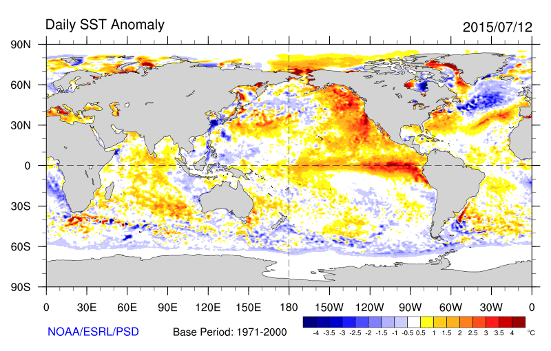
(Extraordinary,
high anomaly suface water heat now extends from the equator all the
way to the polar zone. Image source: NOAA
ESRL.)
According
to NOAA’s
most recent El Nino Report,
Nino 3.4 values hit the strong El Nino threshold for the second week
of July, 2015. Rising to +1.5 C above decadal averages, this region
of the Central Pacific warmed into a hot zone reserved only for the
most intense of El Ninos. A level that must be maintained for three
months for a strong event to be declared. But as of last week, we’d
crossed into that ominous territory.
This
crossing of the strong El Nino threshold occurred even as extreme hot
water anomalies extended up from the Equator, along the US West Coast
and up into the Arctic Ocean itself. A set of anomalies that helped
push PDO values into an also strong range of +1.5 for June, a
re-intensification that ocean surface temperature signatures indicate
is likely to further heighten through July.
Third
Strong Warm Kelvin Wave Likely on the Way
Though
Nino 3.4 just tipped into the strong event threshold this week,
heating along the Equator was most intense in regions closer to South
America. Nino 1+2, just off the coast saw values hit a +3.3 C
positive anomaly. And Nino 3 ranged into +2.1 C territory. Though not
yet near the 1998 peak monthly thresholds (just above 4 C for Nino
1+2 and near 3.5 C for Nino 3), these values are rapidly closing the
gap.

(Cool
Kelvin Wave is crushed by June-July westerlies as a Third Warm Kelvin
Wave begins to develop at depth in the region of 170 East Longitude.
Image source: NOAA
El Nino.)
Nudged
by a still ongoing Westerly Wind Burst (WWB), it appears another warm
Kelvin Wave is starting to gather steam. This after a ‘cool’ wave
was crushed by powerful cyclone development in the Western and
Central Pacific during the past two weeks. Wind anomaly potentials in
this region have been quite strong and widespread — rivaling the
intensity of the record WWB of March of 2015 and showing an even
broader zonal coverage.
Models
are Still Going Bonkers
Last
week, forecast models began to pick up the signal of this new and
implied potential third warm Kelvin Wave development. Now, these same
models show a heightened risk for record El Nino development with El
Nino, in many cases, predicted to remain in the monstrous to record
monstrous range from now until the winter of 2015-2016. PDF corrected
model runs indicate an event that peaks out in the range of 2 C
positive seasonal anomaly in the Nino 3.4 zone (just shy of the
record 1998 event). Uncorrected ensemble runs including the ECMWF
model show a much more extreme El Nino peaking out at 2.9 C positive
anomaly in the seasonal average.
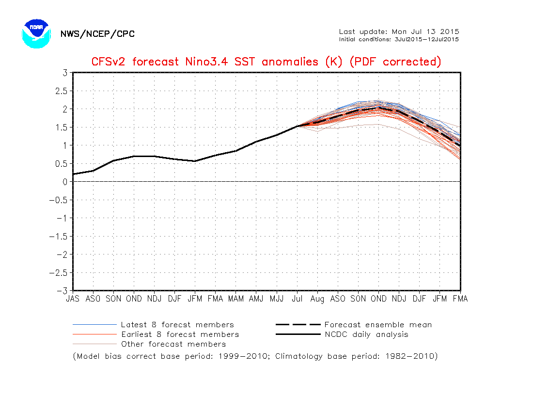
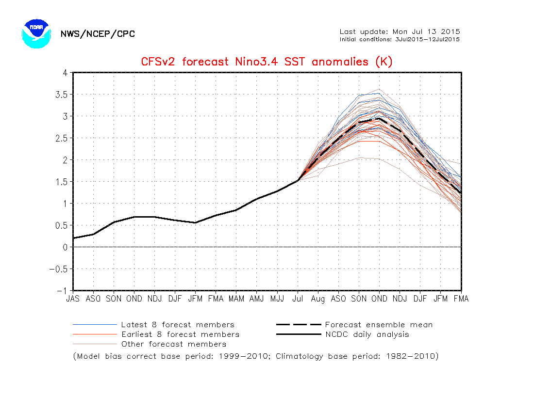
(NOAA
model runs showing near record monster El Nino [top frame] and record
monster El Nino [bottom frame] predicted to peak in October, November
and December of 2015. Image source: NOAA
CFS.)
An
event of this kind would truly be a monster to settle all the record
books. It’s an event we really, really don’t want to see. One
that would likely push the already extraordinary +0.75 C above 20th
Century temperatures we have for 2015 so far even higher. But it’s
one that global forecast tools keep predicting with increasing
certainty. It’s in the models constantly now. An endless litany
week after week — deep ocean warming is coming back to haunt us.
Links:
No comments:
Post a Comment
Note: only a member of this blog may post a comment.