

Steaming
Equatorial Pacific Sees Winds Blowing Toward Monster El Nino
6
May, 2015
Last
year, we raised a
warning that the 2014-2015 El Nino could develop into a monster
event.
And, unfortunately, there is some indication that conditions may well
be continuing in that direction.
*
* * *
All
across the broad belt of the Equatorial Pacific, sea surface
temperatures are running in the hot-to-extraordinarily hot range.
Starting just north and east of New Guinea, 1 C + above average
temperature anomalies run uninterrupted to a zone near the date line
where they encounter a hot pool in the range of +2.6 to +3.1 C above
average. Running eastward, these high heat anomalies gradually taper
off to +1.4 to +1.7 C along a 5,000 mile stretch before they again
spike to +3 to +4 C above average just off the west coast of South
America.
A
massive zone of above average sea surface temperatures encompassing
almost the entire width of the Equatorial Pacific:
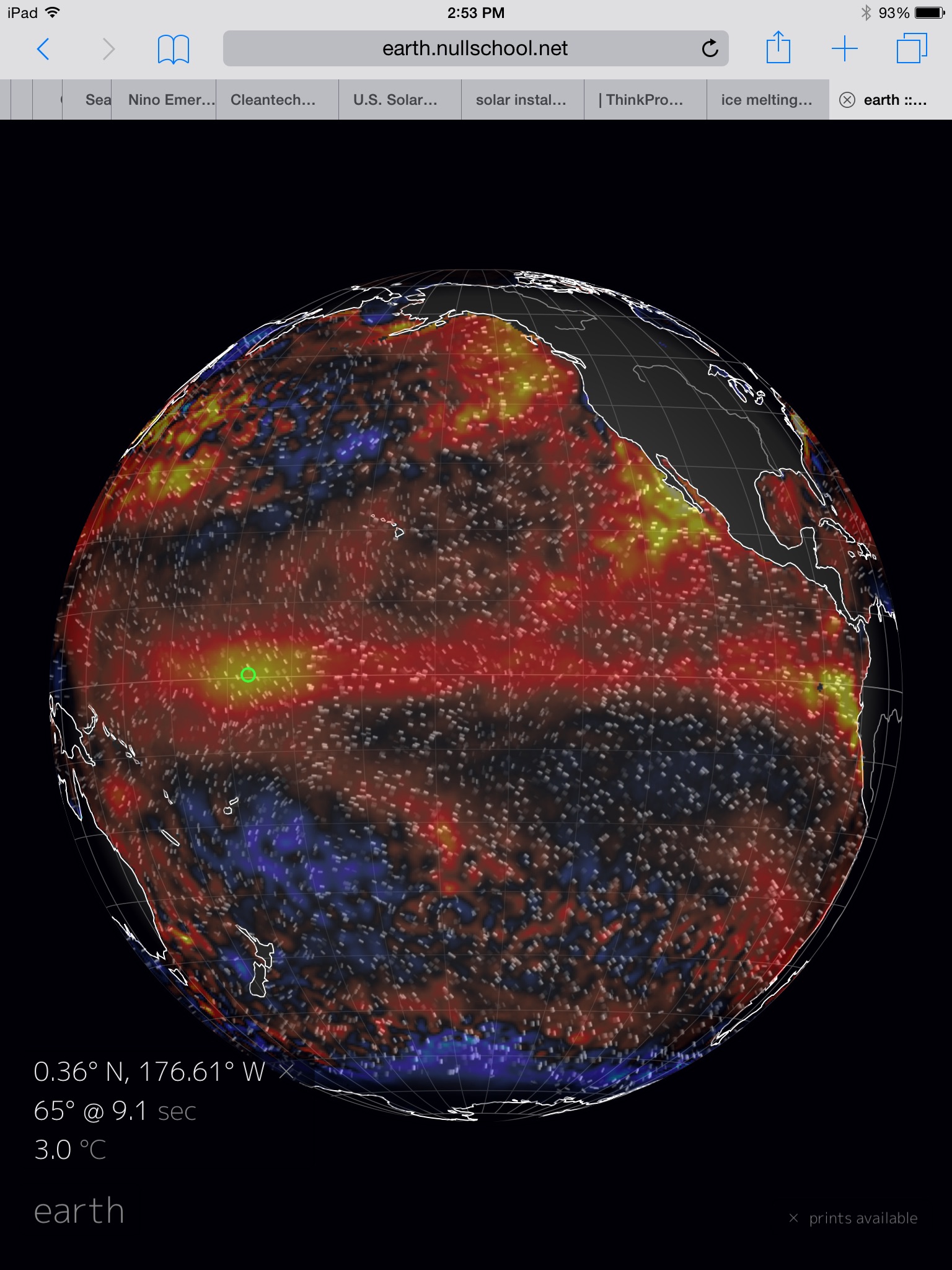
Hot
equatorial waters in a Pacific Ocean that, from Arctic north to
Austral south, from East Asian shores to the west coasts of the
Americas is a morass of record high temperatures. An ocean zone
featuring few and dwindling pools of lower than average readings. Ocean undergoing
rising rates of heat-related sea creature die offs in waters that,
when they warm, lose vital oxygen and host toxin-producing microbes
that thrive in hot water.
It’s
a freakishly hot Pacific. A strange ocean. One that we aren’t quite
accustomed to. One in the grips of what is already a moderate
strength El Nino. An El Nino that, combined with an extraordinary
human greenhouse gas heat forcing, has pushed global surface
temperatures into record high range for 2014 and the first three
months of 2015 thus far. An El Nino which is now threatening a new
leap to monster status.
For
a powerful Kelvin Wave is presently lending heat to equatorial
surface waters after receiving a boost from gale force westerly winds
associated with the
strongest Madden Julian Oscillation on record this past March.
An raging equatorial heat engine that is now drawing yet more energy
from a second set of strong westerlies developing this week.
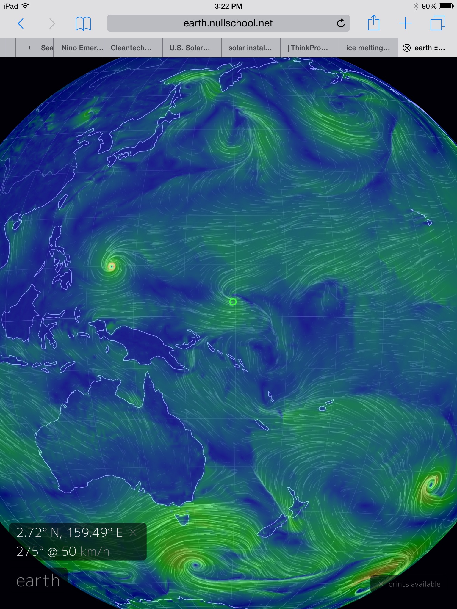
(Strong
westerlies emerging in the Western Pacific on May 6 may provide yet
another boost to the 2014-2015 El Nino. Image source: Earth
Nullschool.)
In
the above GFS summary, we find sustained winds in the range of 30 mph
with gale force gusts in a region along and just north of the Equator
near New Guinea. The winds are in association with a developing
cyclone, one that models indicate will reach strong Typhoon status
later this week. The westerlies stretch westward along the back of
New Guinea and on toward the Philippines. There, they receive a boost
from another cyclone — Tropical Storm Noul.
The
result is a brisk set of westerlies running against the trades along
hundreds of miles of open ocean. The kind of event with the potential
to further strengthen an El Nino that is already at respectable
intensity.
This
week’s CFSv2 NOAA forecast models continued to indicate an extreme
strength El Nino by later this year. Weighted models are now showing
seasonal anomalies in the Nino 3.4 zone peaking out at +2.3 C.
Weighted monthly models are showing peaks in the range of +2.5 C
above average for Nino 3.4. And unweighted models are showing peak
averages that now exceed +3.1 C. This is a jump from last week’s
CFSv2 forecast. Another set in a continued trend for higher
intensity.
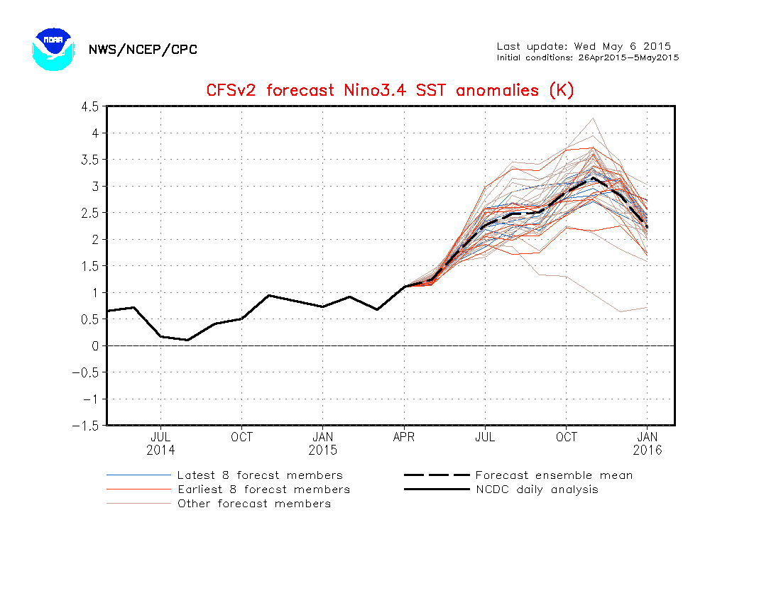
(NOAA’s
forecast models show potential for extreme El Nino starting in June
and extending into January. Image source: NOAA.)
Should
such an event emerge it would truly be a monster. Something far worse
than even the Super El Nino of 1998.
An
extraordinary El Nino of this kind would have far-reaching climate
and weather related impacts. It would push global temperatures into
ever more dangerous ranges. It would strain global carbon sinks. And
it would worsen drought and/or set off heavy precipitation events in
various, already vulnerable regions of the globe. With model
forecasts continuing to hit higher values, with so much available
heat to fuel El Nino ranging the Pacific, and with strong westerlies
continuing to reinforce the current El Nino, this is a situation that
bears very serious continued monitoring.
Links:
No comments:
Post a Comment
Note: only a member of this blog may post a comment.