

Hawaii
in a Sea of Storms: Abnormally Warm Pacific To Serve Up Unprecedented
Double Cyclone Strike?
6
August 2014
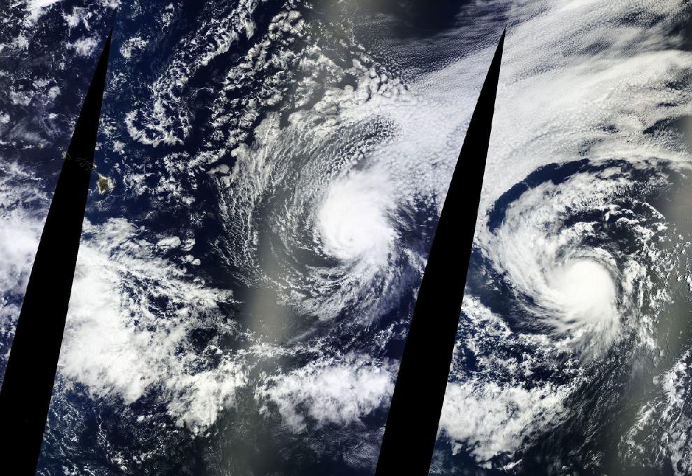
(Iselle
[center frame] and Julio [right frame] take aim on Hawaii [upper
left] in most recent LANCE
MODIS satellite
shot.)
The
Northern Pacific has been a very hot place this year. Above the
Equator and stretching from Asia to the West Coast of North America,
very few regions have witnessed below normal temperatures. And
numerous very large hot zones continue to dominate off of Central and
North America, between Alaska and Russia, and near Japan.
Overall,
Pacific Ocean temperatures today are an excessive +0.93 degrees C
above the, already hotter than normal, 1979 to 2000 average. And this
extra heat, fueled by global warming, provides energy for the
propagation of tropical cyclones well outside of their traditional
ranges.
For
Hawaii, this means falling under threat of two cyclone strikes within
the period of as many days.
Hot
Pacific Waters Projected to Spawn More Hawaiian Storms
Cyclone
strikes in Hawaii are rare. The last time the island state was
pummeled by a tropical storm was during the 1992 El Nino. But now it
is threatened by not one, but two hurricanes. It is an event that is
unprecedented in the entire satellite record. In other words, we’ve
never seen this before.
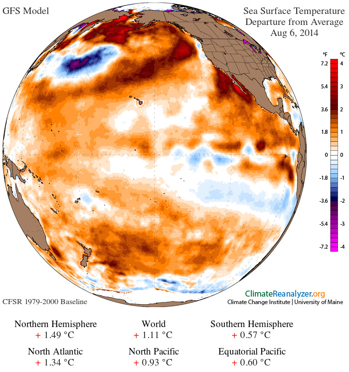
(Global
sea surface temperature anomaly on August 6, 2014, shows an extreme
+1.11 C positive temperature departure for the globe and a very
strong +0.93 positive temperature departure for the North Pacific.
Current science shows that warming ocean waters are extending the
northward ranges of tropical cyclones, bringing regions like Hawaii
under increasing threat. Image source: University
of Maine.)
A
shift in hurricanes toward Hawaii wasn’t entirely unexpected,
however.
In
2013, Hiroyuki Murakami, from the International Pacific Research
Center at the University of Hawaii at Mano together with a team of
ocean and atmospheric researchers produced a report
for Nature entitled Projected
Increases in Cyclones Near Hawaii.
The study modeled expected increases in Pacific Ocean surface
temperature driven by human-caused climate change in the region near
Hawaii. What it discovered was a marked increase in storm formation
near Hawaii due to warming waters and related atmospheric changes.
The
paper notes:
A key factor in projecting climate change is to derive robust signals of future changes in tropical cyclone activity across different model physical schemes and different future patterns in sea surface temperature. A suite of future warming experiments (2075–2099), using a state-of-the-art high-resolution global climate model1, 2, 3, robustly predicts an increase in tropical cyclone frequency of occurrence around the Hawaiian Islands.
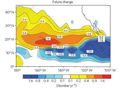
(Change
in tropical cyclone frequency between now and 2075-2090 according to
model projections produced in the Murakami Paper. Image
source: Nature.
See Also: Climate
Change May Increase Number of Hawaiian Hurricanes)
What
these researchers might not have expected was that a very warm
Pacific during 2014 might well provide a prelude to what their models
were predicting.
Iselle
and Julio Barreling On In
For
forecasts now show that Hawaii may well be in for a dose of double
trouble — an extended period of stormy conditions starting early
Friday and possibly not letting up until Monday as the unheard of
storm pair barrels on in.
As
of the most recent advisory, 85 mph hurricane Iselle was located
about 650 miles to the east and southeast of Hilo. Iselle’s present
and projected motion toward the west and northwest at around 15 miles
per hour is expected to bring the storm, at a strong tropical storm
intensity, over Hawaii’s Big Island by Friday. The storm is then
projected to pass near the eastern islands before tracking back out
into the open Pacific.
Coming
directly behind Iselle, Julio is located about 1600 miles
east-southeast of Hilo and packs maximum sustained winds of 75 miles
per hour. The storm is also expected to weaken to strong to moderate
tropical storm status before passing over or near the Hawaiian Island
Chain along a track just to the north of Iselle’s path. This would
bring the storm near the islands on Sunday, just two days after
Iselle.
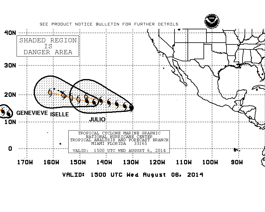
(Threat
cones for Iselle, Julio and Genevieve, all developing in an unusual
region near the Central Pacific. Image source: NOAA.)
It’s
worth mentioning that a third storm, Genevieve, has also developed in
the mid-Pacific within about 1,000 miles of the Hawaiian chain —
also in a rather rare region for tropical cyclone formation.
Genevieve, however, is not expected to threaten the islands as it
tracks westward, taking a long journey toward Asia.
Conditions
in Context
These
three cyclones generated over warm waters near the central equatorial
Pacific. The storms emerged from a convective pattern in a region
that typically only shows robust storm development during El Nino.
Though
El Nino is not officially ongoing, atmospheric conditions over the
past few weeks have become more favorable even as a new warm Kelvin
Wave appears to be forming in the waters of the Western Pacific. NOAA
still forecasts a weak to moderate El Nino for 2014, but conditions,
though somewhat more favorable, remain murky.
It’s
worth noting that a rash of storms in this region is unprecedented in
the satellite era and is especially odd considering that ENSO remains
neutral. It is very likely that the outbreak is in some way related
to the larger Pacific Ocean warming trend associated with
human-caused climate change acting together with an El Nino-like
development trend.
Links:
Hat
tip to Eleggua
No comments:
Post a Comment
Note: only a member of this blog may post a comment.